Thursday, October 25, 2007
Neck deep
My role in the second project is just beginning to ramp up as I joined the team last week. It's a steep learning curve as they are working on the third phase of the business case and more times than not I've felt super-dumb this week.
Oh, and the meetings! I'm neck deep in meetings. I was told earlier this week that one's profile can be measured by the number of meetings one's invited to, and if that's the case, I'd rather be a nobody because while meetings can be useful, it's hard to find time in the day to do any real work when you're in a meeting or preparing to go to a meeting during business hours. This is why I've been bringing work home the last few nights.
I actually brought work home tonight, but I forgot an email that had all my notes on it...I don't know how I could have forgotten it since I brought everything that was on my desk home with me. I was in a rush to leave after meeting with the consultant until 6:30 tonight. I triple-checked my file folder and my notebook and it's not there. So I'm beginning to wonder if I might have recycled it by accident...which would TOTALLY suck eggs!! Grrr!
So...instead of working, I've decided to give in and just chill for the rest of the night. I've only one meeting tomorrow, and the consultant I've been working closely with won't be in the office so I should be able to breathe a bit easier. Keeping my fingers crossed that I placed the email in my desk drawer by mistake...
Sunday, October 21, 2007
Lima: City of Kings
So, without further ado...
We arrived in Lima after midnight on the 16th of August and found out from our cab driver that an earthquake had struck about an hour after we had left Toronto. The quake registered a 7.9 on the Richter scale and caused significant damage. We didn't know at the time what to think - as we drove through the city towards our hotel in Miraflores, we didn't notice anything unusual. There seemed to be electricity as evidenced by the bright lights of the many casinos en route, and the roads appeared to be in good repair.
We found out the next day after our friends came to pick us up in a van for a private city tour that the epicentre was about 150km southwest of Lima although aftershocks were felt in the city centre. They had arrived several days earlier and were in the market at the time negotiating the price for a painting when they felt the ground undulate. Thankfully, CC, who had grown up in Lima, was with them, so they knew what to do. How lucky were we to have missed a quake by 1/2 a day? I don't know what I would have done.
Our first day was spent driving around in a van, with CC acting as our tour guide. The original plan included a stop at the Museo de la Nacion,an anthropological and archaeological museum dedicated to the study of the art and history of the aboriginal people of Peru, but it was closed to check for possible structural damage, so our tour stopped at the Plaza de Armas, which has been declared a world Heritage site by UNESCO. Around the Plaza de Armas stand the Palacio de Gobierno, the Cathedral and the Archbishop's Palace, the Municipalidad, and the Club Union.


Lover's Park at Miraflores and the arts and crafts market not too far from Chinatown with its many colourful storefronts selling alpaca goods...
Cuzco: Ancient Capital of the Incas
Of the two cities I visited, I liked Cuzco best. Lima was too big and crowded with her 8,000,000 inhabitants - Cuzco seemed far more friendly and quaint - but that's probably because it's so touristy. My bias may also be due to the fact that we spent a couple extra days here after our 4-day hike of the trail - the skies were blue, the temperatures warm and we explored at a leisurely pace, which was a welcome change from having spent the last few days trying to keep up on the trail.
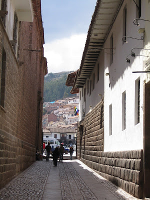
One of many streets with their smooth, Incan-made walls that remain to this day
We spent part of our first full day visiting Santo Domingo (below), the Catholic church built on the remains of what was once the centre of Inca society,The Golden Palace and Temple of the Sun.

And finally, on our way up to the San Blas district, where you'll find a concentration of little shops that sell local carvings, paintings and ceramics, as well as many affordable restaurants:


Urubamba Valley

Our next stop was at the village where our porters, or "angels" are from. We stopped to feed the llamas and alpacas and had the chance to buy handmade crafts made in the ancient tradition.

View from the bus
The next scheduled stop was at the ruins of Pisac, which are perched on the mountain 30 km north of Cuzco:


***********
Update October 25: There was an article in today's Star about the Sacred Valley of the Incas, which is what the Urubamba Valley is also known as, and it covered all the sites in this post and more. Click here for more information if you are so inclined.
The Inca Trail
We camped for three nights along the trail and there was no electricity so I had to conserve my camera battery for Machu Picchu.
Passage along the Inca Trail is strictly regulated in order to preserve it: A maximum of 500 visitors per day are allowed onto the trail - and this includes porters, who are not permitted to carry more than 25kg. According to Manny, the split is 40% visitors, 60% porters. The porters were truly our "angels" since they carried all our supplies along the trail including the tents and sleeping bags, all the food, the propane tanks to cook with and our baggage. All we had to carry was a day pack with essentials for the hike like water, snacks and camera.
Our hike began at Km 82, Piscacucho at 2600m. It is at this checkpoint where everything the porters carry along the trail is weighed. I must confess that anything beyond getting through the checkpoint is a blur to me. I can't remember if this leg of the trail was particularly steep, or whether it was uphill or downhill. I can tell from the few photos I took that we hiked pass a small ruin and spied the snow-capped Cordillera Vilcabamba, affectionately known as Veronika's Tears, in the distance before settling for the night in Wayllabamba.
Day 2 was my hell day as the trail was mostly uphill to Warmiwanusca, or Dead Woman's Pass at 4200m, the highest point of the hike. Here's the fairly innocuous start:

...and here's the view from the peak of Dead Woman's Pass:
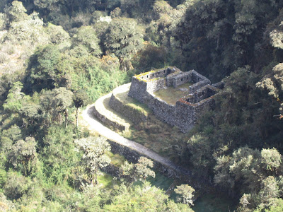
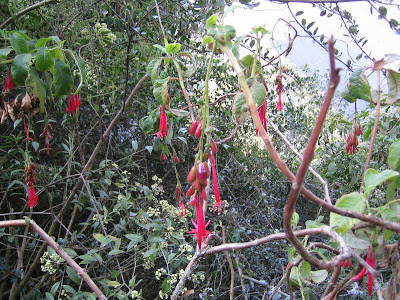
After the uphill battle that was Day 2, it was pretty much all downhill on Day 3, which I found MUCH easier. I also relaxed a bit and took more pictures - mostly of the flora of which there was plenty, as you'll see, and more ruins:


Orchids


