This is the part of the trip in which I lack photographic evidence - I know it looks like a lot here, but there was so much more to see! I was the slow poke in our group of 7 on this hike. Manny, our guide - bless him! - kept me company as I huffed and puffed along the trail: "Remember, don't compete, just complete!"
We camped for three nights along the trail and there was no electricity so I had to conserve my camera battery for Machu Picchu.
Passage along the Inca Trail is strictly regulated in order to preserve it: A maximum of 500 visitors per day are allowed onto the trail - and this includes porters, who are not permitted to carry more than 25kg. According to Manny, the split is 40% visitors, 60% porters. The porters were truly our "angels" since they carried all our supplies along the trail including the tents and sleeping bags, all the food, the propane tanks to cook with and our baggage. All we had to carry was a day pack with essentials for the hike like water, snacks and camera.
Our hike began at Km 82, Piscacucho at 2600m. It is at this checkpoint where everything the porters carry along the trail is weighed. I must confess that anything beyond getting through the checkpoint is a blur to me. I can't remember if this leg of the trail was particularly steep, or whether it was uphill or downhill. I can tell from the few photos I took that we hiked pass a small ruin and spied the snow-capped Cordillera Vilcabamba, affectionately known as Veronika's Tears, in the distance before settling for the night in Wayllabamba.


Day 2 was my hell day as the trail was mostly uphill to Warmiwanusca, or Dead Woman's Pass at 4200m, the highest point of the hike. Here's the fairly innocuous start:


 Yellow Orchids also known as "Dancing Queens" along the trail
...and here's the view from the peak of Dead Woman's Pass:


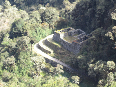
After the uphill battle that was Day 2, it was pretty much all downhill on Day 3, which I found MUCH easier. I also relaxed a bit and took more pictures - mostly of the flora of which there was plenty, as you'll see, and more ruins:


 A Tatinger (sp?) I caught resting on a branch
 Amidst the Cloud Forest


 At the top of one of the many steep flights down the trail


Orchids
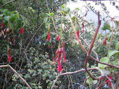
 Fuschias
 I don't remember what this flower's called, but it reminds me of a very leggy insect
Finally, the last ruin before Machu Picchu, Winaywayna, or Forever Young, which was not too far from our final camp site:

 More fuschias
 Begonias


 Plaza de Armas with The Cathedral in the background


 The central courtyard of Santo Domingo


